Дѣло:Americas (orthographic projection).svg

Size of this PNG preview of this SVG file: 550 × 550 пиѯєлъ. Other resolutions: 240 × 240 пиѯєлъ | 480 × 480 пиѯєлъ | 768 × 768 пиѯєлъ | 1.024 × 1.024 пиѯєлъ | 2.048 × 2.048 пиѯєлъ.
источьнъ дѣла обраꙁъ (дѣло SVG · обꙑчьнъ обраꙁъ : 550 × 550 п҃ѯ · дѣла мѣра : 332 Х҃Б)
| Сь видъ Викикладѣ (Wikimedia Commons) съхранѥнъ ѥстъ ⁙ Cѥ ѥгожє опьсаниѥ ѥстъ |
опьсаниѥ
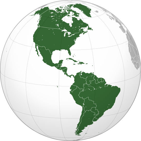
| опьсаниѥ | Orthographic map of the Americas with national borders added |
| врѣмѧ сътворѥниꙗ | |
| кладѧꙃь | своѥ творѥниѥ |
| творьць | Martin23230 |
| Other versions |
.svg) |
| SVG genesis |
.svg)
.svg)
.svg)
.svg)
.svg)
.svg)
.svg)
.svg)
.svg)
.svg)
.svg)
.svg)
.svg)
.svg)
.svg)
.svg)
.svg)
.svg)
.svg)
.svg)
.svg)
.svg)
.svg)
.svg)
.svg)
.svg)
.svg)
.svg)
.svg)
.svg)
.svg)
.svg)
.svg)
.svg)
.svg)
.svg)
.svg)
.svg)
.svg)
.svg)
.svg)
.svg)
.svg)
.svg)
.svg)
.svg)
.svg)
.svg)
.svg)
.svg)
.svg)
.svg)
.svg)
.svg)
.svg)
.svg)
.svg)
.svg)
.svg)
.svg)
.svg)
.svg)
.svg)
.svg)
.svg)
.svg)
.svg)
.svg)
.svg)
.svg)
.svg)
.svg)
.svg)

.svg)

.svg)

.svg)
.svg)
.svg)
.svg)
.svg)
.svg)
.svg)


.svg)
.svg)
.svg)
.svg)
.svg)
.svg)
.svg)

.svg)
.svg)
.svg)
.svg)
.svg)
.svg)
.svg)
.svg)
.svg)

.svg)
.svg)
.svg)
.svg)
.svg)
.svg)
.svg)
_without_national_boundaries.svg)
.svg)
.svg)
.svg)
.svg)
.svg)
.svg)

.svg)
.svg)
.png)
.svg)
.svg)
.svg)
.svg)

.svg)
.svg)
.svg)
.svg)
.svg)
.svg)
.svg)
.svg)
.svg)
.svg)
.svg)

.svg)
.svg)
.svg)
.svg)
.svg)
.svg)
.svg)
.svg)
.svg)

.svg)
.svg)

.svg)
.svg)
.svg)
.svg)
.svg)
.svg)
.svg)
.svg)
.svg)
.svg)
.svg)
.svg)
.svg)
.svg)
.svg)
.svg)
.svg)
.svg)
.svg)
.svg)
.svg)
.svg)
.svg)
.svg)
.svg)
.svg)
.svg)
_-_Crimea_disputed.svg)
.svg)
.svg)
.svg)
.svg)
.svg)
.svg)
.svg)
.svg)
.svg)
.svg)
.svg)
_political.svg)
.svg)
.svg)
.svg)
.svg)
_-_Crimea_disputed_-_no_borders.svg)
.svg)
.svg)
.svg)
.svg)
.svg)
.svg)
.svg)
.svg)
.svg)
.svg)
.svg)

.svg)
.svg)
.svg)

.png)
.svg)
.svg)
.svg)
.svg)
.svg)
.svg)
.svg)
.svg)
.svg)
.svg)
.svg)
.svg)
.svg)
.svg)
.svg)
.svg)
.svg)
.svg)
.svg)
.svg)
.svg)
.svg)
.svg)
.svg)
.svg)
.svg)
.svg)
.svg)
.svg)
.svg)
.svg)
.svg)
.svg)
.svg)
.png)
.svg)
.svg)
.svg)
_(orthographic_projection).png)
.svg)
.svg)
прощєниѥ
I, the copyright holder of this work, hereby publish it under the following licenses:
сѥ́ дѣ́ло по́дъ прощє́ниѥмь Creative Commons Attribution-Share Alike 3.0 Unported положєно ѥ́стъ
- тꙑ можєши :
- прострѣти – to copy, distribute and transmit the work
- прѣвращати – прѣтворити дѣло
- Under the following conditions:
- attribution – You must give appropriate credit, provide a link to the license, and indicate if changes were made. You may do so in any reasonable manner, but not in any way that suggests the licensor endorses you or your use.
- share alike – ащє жє сѥ дѣло иꙁмѣниши · прѣвратиши или ѥгожє основѣ нѣчьто сътвориши · тъ авлѥно слѣдьствиѥ подъ самомь тѣмь прощєниѥмь или подобьномь ѥмоу положити длъжєнъ ѥси

|
Permission is granted to copy, distribute and/or modify this document under the terms of the GNU Free Documentation License, Version 1.2 or any later version published by the Free Software Foundation; with no Invariant Sections, no Front-Cover Texts, and no Back-Cover Texts. A copy of the license is included in the section entitled GNU Free Documentation License. |
прощєниѥ иꙁбрати можєши
дѣла їсторїꙗ
Click on a date/time to view the file as it appeared at that time.
| дьнь / врѣмѧ | малъ обраꙁъ | мѣра | польꙃєватєл҄ь | опьсаниѥ | |
|---|---|---|---|---|---|
| нꙑнѣщьн҄ь обраꙁъ | 22:24, їоулїꙗ 18 числа, 2016 | | 550 × 550 (332 Х҃Б) | Turnless | Reverted to version as of 04:48, 5 December 2009 (UTC) Hawaii is in Oceania |
| 02:05, апрїлїꙗ 30 числа, 2013 |  | 550 × 550 (1,44 MB) | Giggette | Centered | |
| 04:48, дєкємврїꙗ 5 числа, 2009 |  | 550 × 550 (332 Х҃Б) | Keepscases | borders | |
| 11:26, аѷгоуста 16 числа, 2009 |  | 541 × 541 (332 Х҃Б) | Bosonic dressing | tweak map: colour St. Lawrence Island (Alaska, USA), draw in missing peripheral latitudinal lines | |
| 16:20, їоунїꙗ 26 числа, 2009 |  | 541 × 541 (318 Х҃Б) | Martin23230 | {{Information |Description= Orthographic map of the Americas |Source=self-made |Date=2009-06-26 |Author= Martin23230 |Permission= |other_versions= }} Category:Orthographic projections Category:Maps of the Americas |
дѣла польꙃєваниѥ
The following page uses this file:
Global file usage
инꙑ мѣста къдє сѥ дѣло польꙃєвано ѥстъ :
- польꙃєваниѥ въ af.wikipedia.org
- польꙃєваниѥ въ am.wikipedia.org
- польꙃєваниѥ въ an.wikipedia.org
- польꙃєваниѥ въ ar.wikipedia.org
- الولايات المتحدة
- عالم غربي
- هندوراس
- فنزويلا
- شعراء المهجر
- آسيا
- أوروبا
- قارة
- تصنيف:قارات
- المكسيك
- كندا
- الأرجنتين
- تصنيف:كوبا
- تصنيف:أمريكا الشمالية
- سيمون بوليفار
- برمودا
- تصنيف:أمريكا الجنوبية
- تصنيف:أرجنتينيون
- المحيط الهادئ
- أستراليا
- القارة القطبية الجنوبية
- كوبا
- بليز
- تصنيف:دول أمريكا
- تصنيف:مدن أمريكية
- اللغة الإسبانية
- تصنيف:دول الكاريبي
- أوقيانوسيا
- تصنيف:أنهار أمريكا الجنوبية
- بوليفيا
- بيرو
- حضارة المايا
- أمريكا الشمالية
View more global usage of this file.
.svg)
.svg)