Дѣло:Danubemap.png
No higher resolution available.
Danubemap.png (747 × 480 п҃ѯ · дѣла мѣра : 601 Х҃Б · MIME тѷпъ : image/png)
| Сь видъ Викикладѣ (Wikimedia Commons) съхранѥнъ ѥстъ ⁙ Cѥ ѥгожє опьсаниѥ ѥстъ |

|
This map image could be re-created using vector graphics as an SVG file. This has several advantages; see Commons:Media for cleanup for more information. If an SVG form of this image is available, please upload it and afterwards replace this template with
{{vector version available|new image name}}.
It is recommended to name the SVG file “Danubemap.svg”—then the template Vector version available (or Vva) does not need the new image name parameter. |
опьсаниѥ
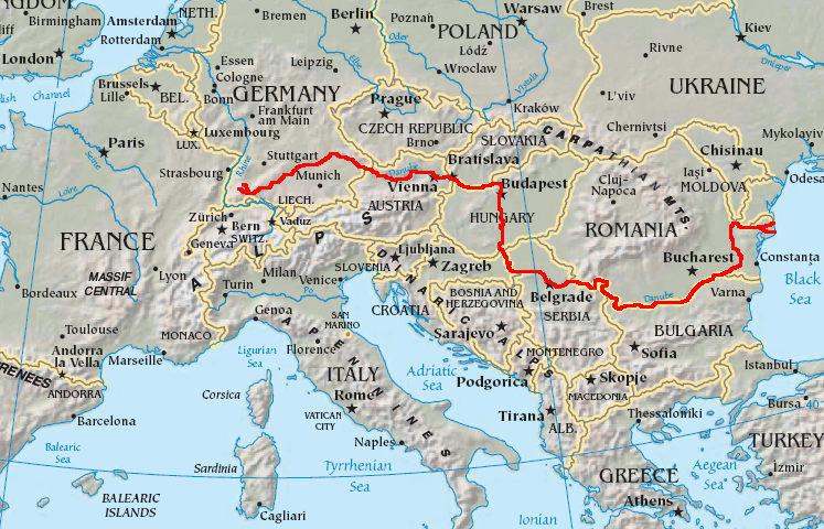
English: Map showing the flow of the Danube River. Uses the map of Europe from the CIA World Factbook.
прощєниѥ
This image is in the public domain because it contains materials that originally came from the United States Central Intelligence Agency's World Factbook.
|
 |
дѣла їсторїꙗ
Click on a date/time to view the file as it appeared at that time.
| дьнь / врѣмѧ | малъ обраꙁъ | мѣра | польꙃєватєл҄ь | опьсаниѥ | |
|---|---|---|---|---|---|
| нꙑнѣщьн҄ь обраꙁъ | 05:34, фєвроуарїꙗ 12 числа, 2007 | | 747 × 480 (601 Х҃Б) | Geologik | Map showing the flow of the Danube River. Uses the map of Europe from the CIA World Factbook. |
дѣла польꙃєваниѥ
The following page uses this file:
Global file usage
инꙑ мѣста къдє сѥ дѣло польꙃєвано ѥстъ :
- польꙃєваниѥ въ ang.wikipedia.org
- польꙃєваниѥ въ ast.wikipedia.org
- польꙃєваниѥ въ av.wikipedia.org
- польꙃєваниѥ въ azb.wikipedia.org
- польꙃєваниѥ въ ban.wikipedia.org
- польꙃєваниѥ въ be-tarask.wikipedia.org
- польꙃєваниѥ въ bg.wikipedia.org
View more global usage of this file.